

- Yet another blast of arctic air will chill the South and East through Saturday.
- After that, the extreme cold will take a break over much of the country.
- This January thaw could last until the end of the month.
- Locations buried by heavy snow recently could instead see rain next week.
A January thaw will arrive next week, providing relief for areas hard hit by a recent parade of winter storms and cold air outbreaks.
Winter fatigue: In less than two weeks’ time, five separate winter storms have hit parts of the country, from Winter Storm Ember in the Northeast in the first weekend of January through the current Winter Storm Indigo spreading from the West into the Midwest and East this week. That’s a full January worth of winter storms, on average.
Then a blast of bitter cold air howled through the eastern two-thirds of the nation. Dillon, Montana, set its all-time record low (minus 41 degrees), the NFL’s Kansas City Chiefs and Miami Dolphins played their coldest game in franchise history (minus 4 degrees), and the lowest temperature in the Lower 48 states Wednesday wasn’t in Montana, but in Kentucky.
Another chilly blast: The nation could use a breather from this. But it won’t happen immediately.
Another blast of cold air will plunge through the Plains and Mississippi Valley Thursday and Friday, then hang out in the Southeast this weekend.
(CURRENT MAP TRACKERS: Temperatures | Wind Chills)
In most areas, this latest cold blast won’t be quite as cold as what we saw earlier this week. But it will still be uncomfortable.
For instance, Saturday morning’s lows are expected to plunge into the 20s below zero in the Missouri Valley, including Omaha, and in the teens below zero in Kansas City. That could flirt with daily record lows. Highs Saturday may struggle to get out of the 20s in parts of the Southeast.
(Further beef up your forecast with our detailed, hour-by-hour breakdown for the next 8 days – only available on our Premium Pro experience.)

Then, the thaw: There is light at the end of this cold tunnel. Beginning early next week, milder air will begin to stream north into the previously frigid Plains, Midwest, then the South.
By Monday and Tuesday, highs will flirt with the freezing mark as far north as the upper Midwest. And in the South, highs in the 50s and 60s will creep into the previously shivering South.
(FORECAST DETAILS: 10-Day U.S. Highs and Lows)

How Long It Will Last: This January thaw may have staying power through the rest of the month. Some of our longer-range guidance suggests at least somewhat colder air could return to parts of the Rockies and Plains around the last day of January or first day of February.

Flies in the ointment: This thaw won’t be accompanied by abundant sunshine. It is January, after all.
This warmer, more humid air flowing over still significant snowpack will lead to areas of fog and low clouds in the Midwest, South and East next week.
And it won’t be dry, either. Precipitation will return, first to the southern Plains Sunday night, then to the Midwest and Northeast Monday and Tuesday.
Since the air will be much milder, that means more of that may eventually fall as rain, rather than snow, in most areas.
This combination of warmer air and rain should melt what’s left of the southern snowpack, and could also put a dent into both the Midwest and Northeast snow cover. That could lead to some flooding, especially in areas where deep snowpack currently blocks storm sewers on city streets. It could also lead to ice jams on some rivers and streams.

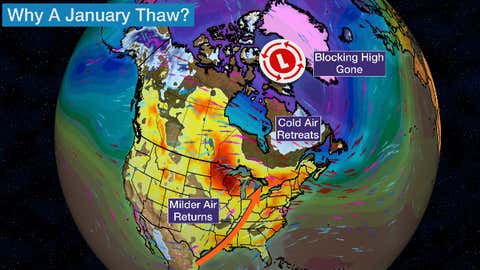
Why The Change? This thaw ahead is basically due to a reversal of the pattern that caused the siege of cold air and winter storms.
Blocking high pressure aloft near Greenland and the Canadian Arctic will disappear, leaving low pressure in its place.
That means a mechanism to force cold air out of Canada into the U.S. won’t be there.
Instead, milder air from the Pacific Ocean will dominate and warmer air will stream northward from the southern U.S. Colder air will be trapped in Canada for awhile.
It’s a pattern that contributed to America’s record warmest December in 129 years and the least Christmas snow cover in 20 years.
MORE ON WEATHER.COM
- How To Prevent Frozen Pipes In Your Home
- Tips For Staying Warm When The Power Is Out
- How To Protect Yourself From Hypothermia
- Historic Cold Waves In US History
Jonathan Erdman is a senior meteorologist at weather.com and has been covering national and international weather since 1996. His lifelong love of meteorology began with a close encounter with a tornado as a child in Wisconsin. He studied physics at the University of Wisconsin-Madison, then completed his Master’s degree working with dual-polarization radar and lightning data at Colorado State University. Extreme and bizarre weather are his favorite topics. Reach out to him on X (formerly Twitter), Threads, Facebook and Bluesky.
The Weather Company’s primary journalistic mission is to report on breaking weather news, the environment and the importance of science to our lives. This story does not necessarily represent the position of our parent company, IBM.